
Your Cart is Empty
Free Domestic Shipping Over $50 | 30 Day Returns


Photos and text by Ryan “dirtmonger” Sylva
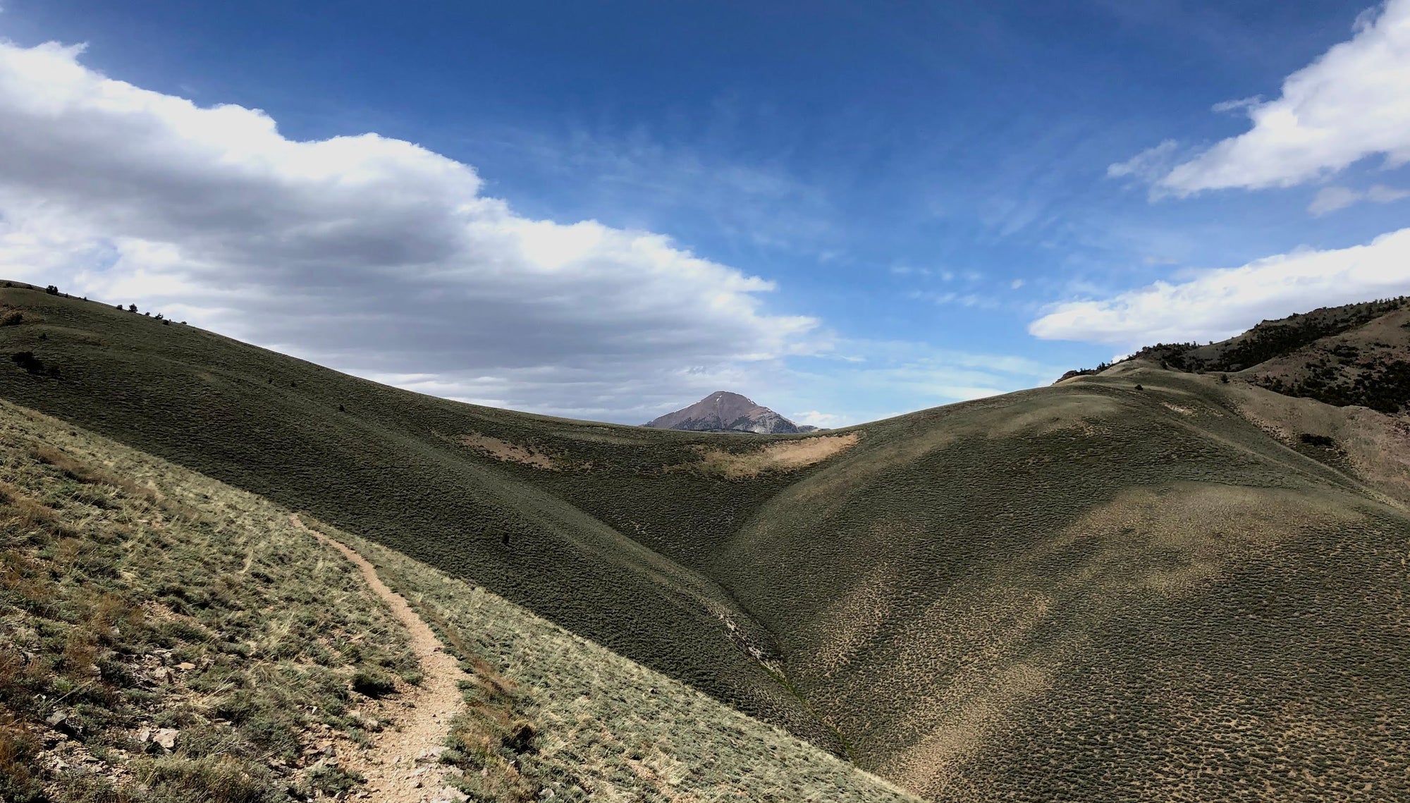
Bunch Brush Canyon in the McKinney Range, a subset range of the Toquima Range, felt thick and wooly with shrubs of all sorts--chamise, sagebrush, bitterbrush. The sweet grass bloomed, the sagebrush stood tall and fragrant. The pinyon showed off green sprigs and the juniper boasted its ashy blue berries. Because of this the canyon air had a redolence of sweetness. I had not planned on this 'way.' I went off feel. I went off the inspiration of wild horses. I had noticed something out here on the Great Basin Trail. Where I found wild horses I found good things: no people, wild trails, water, and a way through.
I followed up-canyon an overgrown two track a few miles or so. The flowering shrubs hung over the two track creating a tunnel and I hurriedly hiked on in hopes of finding a camp spot as the purple rays of light began to sink in the basin below. As dusk closed the curtain of another splendid day out here in the Great Basin, I found a camp at a piped spring pouring into a round trough next to a stalwart pinyon, the largest I have ever seen. The two track ended. This was as far as most folks would venture into this remote canyon. I guzzled much, as I had the surplus to do so, and cozied into my quilt for a chilly night.

At the crack of dawn I woke up to water flowing out of a metal pipe, the end of the stream plunging into a tiny opening of unfrozen water in the trough. I packed up quickly in the boring cold, then maneuvered through the esses of the canyon. As the canyon became narrower, it became choked with plant life. I picked my way through and persisted towards the saddle between some rocky turrets. With no sign of animal trail I wondered when was the last time a person had gone this far into the narrow reaches. I scrambled up a chossy hillside to attain a broad flat. I scanned the hillsides that had veins of rock ledges sticking out of the pinyon and mahogany forests, like a bear trap.
Little Cottonwood Canyon plummeted into a narrow squeeze of pinched crimson rock, the drainage lined with the canyon's treed and trembling namesake. I side-hilled over to a low pass on the ridgecrest and found tread to trample on that led right to the canyon's headwater spring. From there a lengthy and exquisite traverse on PCT style tread ensued. Not on a map - this is what is special about the Great Basin Trail. Free form nature within a wild nature. You see sign of life traveling. However, the sign is of wildness, an erratic nature of what is beyond our control; this instinct of animal in nomadic form, this survival within harshness, this necessity without convenience -- all right there to the observer in the form of a path.

Under the range's high point plateau, I finally hit the broad ridge above Big Cottonwood Canyon. I felt very fortunate to have ambled through an area otherwise unknown, for an unknown path became a clear path. I had many cows and wild horses to thank. I meandered through the rest of the McKinney Range in a day following lonesome paths. I set up a cowboy camp in the adjacent basin.
In the wee hours of that night, I woke up to some shaking in Ralston Valley. An earthquake moaned and groaned in the basin. I had laid down in an indiscernible wash lined with saltbrush. I groggily lifted my head and noticed the light blue glow of the eastern horizon as the sun slowly began rising. My first thought became washed over by my realization that I was experiencing an earthquake. I thought the tremor felt small but I knew immediately I had no frame of reference. The trembling continued on for a few long seconds and I laid my head back down on my sleeping pad. Surreal, utterly surreal. I must have fallen quickly back to sleep after being somewhat Los Angeles apathetic---earthquakes were common where I grew up. Couple that notion with being in the middle of nowhere and I did not comprehend the impact of what had just occurred. A few minutes later I woke up in a different type of silence---an earthquake silence, which if you grew up in an earthquake zone you would know--- coyotes yipped and barked like domestic dogs and I instantly knew what was about to occur. The moment felt like Northridge in 1994. The basin floor groaned and moaned again, bellowed as the ground rolled; no walls, no edifications, and I thought: 'Well, I'm okay as long as the ground does not open up.'
I rolled over and went back to sleep feeling so isolated and apathetic, simply feeling a different yet non-threatening experience. But the silence, the incredible silence of an earthquake on a lonesome and still night was unlike anything I have ever experienced. The sensation still wells up inside of me to this day.

I woke up at dawn and began the ramble to my food cache. The terrain lazily rolled up over a small range, the southern finger of the Toquimas. I sauntered up wide washes, grey with rock, almost ash-like, until I saw the grand Toiyabe beckoning in the distance.
The Toiyabe Crest is arguably the highlight of the Great Basin Trail. The Toiyabe Range is 120 miles long and one of the largest and longest mountain ranges in the state of Nevada. The plan was to intersect the Toiyabe Crest Trail, amble 25 miles of it, and veer east off the range and down Ophir Canyon. I chose to utilize only 25 miles of the TCT for the GBT because of the effort to get east and to massively swing back towards the Alta Toquima. Due to the remoteness of the GBT, I felt the need to keep sections achievable for hikers. Another advantage is when departing the TCT at Ophir Summit one ends up at Highway 374 where Ophir Road terminates in the Big Smoky Valley. At this highway intersection, I had a food cache. Plus, the GBT is within 10 miles of the small town of Carvers, which has all, although minimum, amenities.
I met my buddy, Pepperflake, at Peavine Campground. He, too, had been out a couple mornings in that tremor. We spent the afternoon hiking up into the Toiyabe and talked about our spooky earthquake experience. Toms Canyon was in good condition and climbing up to the pass afforded us views of Arc Dome, the highest point in the Toiyabe. Below, the Reese River flowed in an otherworldly presence. We were in high country and deep in the mountains, but the dry desert loomed below in the distance. As we set up camp that night, the wind howled and we used some willows as buffering from the wind. I gazed up and wondered if a storm system was coming in.

The next morning, Arc Dome stood smothered in clouds. We picked our way up to the spine of Arc Dome and the wind screamed from the western skies. Puffy stratus clouds and mist made the air smell like water vapor. We did not dilly-dally along the crest as the biting cold penetrated our skin through our clothes. After a speedy push, we finally were awarded with a spot of sunshine and wind coverage. We warmed up for a spell, then moved forward. We could see the range to the west draped in rain clouds and we suspected that the Toiyabe Crest was next. At Ophir Summit, we left the wilderness boundary and took a quick second to look below at the Big Smoky Basin. We could not look to the Reese River Valley to the west because the storm hit the crestline. Instantly the sky went dark gray as clouds slammed into the crest and waved over into the Ophir drainage. It was as if we were meant to be there at that exact moment, the crossroads of doom.
Huge drops of rain fell and we descended quickly. After an hour or two, we hiked on, soaked and cold, and I found an old stone hut once used by miners near the mining ghost town of Ophir. The dilapidated roof kept somewhat intact from the thick beams of wood spanning the hut's walls. The hut felt instantly warmer than being out in the rain. In the center and at the rear wall, a rusted and smoke-stained chimney connected to the fire pit below it. Somewhat fresh ashes laid in the pit and Pep started a fire. We crouched close to the flames and warmed and dried our sopping wet clothing and skin. The rain pelted the tin roof. We hunkered down, ate lunch, and I almost fell asleep in my crouched position. Clearly, we were safe and warm. After a couple hours the sky felt more stable and we took off, dry and warm, to the highway to gather our caches.

The Toquima Range is very tall in stature, abruptly tall even. The range is characterized by a very large plateau of subalpine tundra on the three summits of Mt. Jefferson. This is the spotlight of the Alta Toquima Wilderness which culminates at the southern high point of Mt. Jefferson at 11,949. This is also the Great Basin Trail high point. Views from the summit are absolutely spectacular as one can see all the way to the Palisade Glacier area of the Sierra Nevada. The views are so vast that one can see the high point of Death Valley National Park, Telescope Peak, to the south. The panorama spans an incredible distance towards these landmarks.
The lead up to the Alta Toquima crosses the wide Big Smoky Valley and contours steeply up through the mesas that lead up to the Alta Toquima. Once across the high alpine plateau, a trail plummets down Andrews Basin and the hiker ends up in the rugged and choked Trail Canyon. Trail Canyon starts off as easy cross country, but once the canyon squeezes, the hiker is then thrashing the way down the rest of the canyon to the alluvial fans above the Monitor Valley.

The extreme exposure in the Alta Toquima is palpable, not only in the vistas and the high plateaus, but on your skin. You are either hot or cold, wind-thrashed or cold-bit, tramping on good trail or bushwhacking through a tangled mess. The rewards are very fulfilling once through the traverse of the Alta Toquima. You feel accomplished, yet lucky in being able to get through unscathed; though your scratched shins and sunburnt cheeks and nose may say differently. For us, we experienced extreme cold and camp on crusty snow at around 9,800ft. We set up our tarps close together and as a windbreak for the fire we started. We gathered firewood for the night to keep us warm, as we expected temperatures to drop between 15-20 degrees. As the sun sank, a pink glow shimmered in the Moore Creek Basin and we felt toasty sitting on a rock near the fire. In the freezing morning, we broke camp quickly and began the slow plod up to the large plateau of Mt. Jefferson on crusty and hard snow. Once atop the plateau, we observed the panorama of many mountain ranges. The Toquima Range continued in a crooked northern line that felt to be a molded topography of a different range because of how high we were. We hiked atop crunchy snow and the sun's refulgence warmed us up. We summited the high point of the broad peak and soaked up the views.

Then we picked our way through the talus fields to Andrews Basin and followed the ribbon of snowmelt roaring in the small creek. I had been waiting for Trail Canyon since I had scoped the route out in 2015. I wanted to efficiently get through without suffering because of how constricted and choked the canyon got. After lunch in a shady alcove, I felt ready to tackle the obstacle. We meandered down the curves of the canyon as the tall and chunky cliffs loomed above us. We even found a bighorn sheep skeleton with the skull still attached to the spine. Some mummified fur still clung to the facial curves of the skull and looked eerily gaunt and alive.
As soon as we came to the choke point, my memory became flooded with my past experience bushwhacking through here. We strove on and I picked the way efficiently and climbed up a gully, over an overlook of the u-bend, and skidded down another talus-filled gully. As the canyon widened, juniper and pinyon became more present and I could see the Monitor Range across the basin. Trail Canyon was not as bad as I thought.
If this taste of the GBT piqued your interest, you can visit the author’s website (http://www.freedirtmonger.com), or contact him at greatbasintrail@gmail.com. PLEASE NOTE THAT AN ADVANCED SKILL SET IN NAVIGATION AND REMOTE HIKING IS REQUIRED FOR THE GREAT BASIN TRAIL.